Before I tell you my story, I should take a moment and explain that I am a Geocacher. Geocaching is a hobby in which people use multimillion-dollar satellites to find Tupperware in the woods. That may be a flip oversimplification. A little more of a concise definition for Geocaching may be: hunting for and finding a hidden container, location, or event using GPS coordinates posted on a website. There are over 3 million Geocaches hidden, worldwide. There are apps that you can use depending on what kind of phone you have. I use a Garman Oregon 450T, handheld GPS for most of my Geocaching trips.
 The hobby became possible May 2, 2000, when the government turned off “Selected Availability” from the geospatial constellation of satellites that enable the Global Positioning System (GPS) to function. On that May day, civilian use of those satellites became 10X more effective. On 3 May the first “GeoStash” was hidden in Oregon to test the accuracy of the newly released satellite capability.
If you are not familiar with Geocaching, you can watch a quick Geocaching 101 video.
Now that you are caught up, I will tell you about my adventure.
I had planned a weekend trip to Savannah to see Jeanne in early April. The weather has been a little crazy since March with some unseasonably cold weather; I was looking forward to a warmer climate and some quality time with Jeanne. I had taken a day off on Friday the 13th and planned to drive south. Jeanne was going to be working; my goal was to arrive in Savannah for dinner.
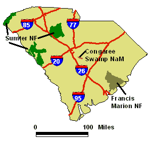
National Forest Map, South Carolina
While planning my trip, I was looking to see if there were any challenging Geocaches along the way to break up the seven-hour drive. I have had my eye on the oldest cache in the State of South Carolina. Modoc Stash (GCF4) was placed in December 2000 in the Sumter National Forest. I have thought about coming here before but have had to change plans because of weather, hunting season or a lack of time. The other issue is that an attempt to find this Geocache would take me over 135 miles out of my way, roughly a three-hour detour off my usual run to Savannah.
Why would a reasonably intelligent man drive 135 miles out of his way to find an ammo can in the woods? If you don’t have the Geocaching bug, you may not get it. There were several draws for this hike. First, it is a Y2K hide. There are less than 175 of the original caches hidden in 2000 still active worldwide. On top of that, it is one of the rare remaining Y2K caches with a four place alphanumeric serial number. Second, it helps me fill in some challenges. I add a new county (McCormick) in South Carolina, fill in a new page for the South Carolina DeLorme Challenge (Page 42). This find qualified me for the April 2018 GeoChallenge of the Month. Yes, I am a geek.

The Trailhead along South Carolina Route 23
I left my house in Chesapeake just after 7 a.m. and began the trek south and west. When I came upon the I-95/I-20 interchange in Florence, South Carolina, I went west on I-20 and started the detour hoping to get past Columbia, South Carolina’s Capitol, before Friday afternoon traffic became problematic. Just after 3 p.m., I exited I-20 west of Aiken and worked my way along country highways until I arrived at the trailhead. There is parking at this location and a geocache, Modoc Trailhead (GC7B2YZ), is very close to the parking area.
I had a backpack with me with water, a couple of Kind bars, and some of my usual Geocaching gear. I also had a walking stick. I usually do not use the Geocaching app on my iPhone for hikes like this one. Instead, I had loaded my Garmin Oregon 450T with the coordinates for the caches along the trail. I had the trailhead marked with the first cache that I mentioned in the previous paragraph, another along the path and finally the goal for the day, Modoc Stash.
I have some recommendations for this hike. First, sturdy hiking boots. Flip flops or sandals are not going to cut it on this trail. Second, be aware of your surroundings. This trail is shared with mountain bikers. You will want to keep a lookout for them. There is also wildlife in the national forest. There are over 48 species of mammals including bears, bobcats, beaver, and deer as well as a variety of venomous and non-venomous  snakes. Finally, you need to stick to the trail until you get within about 200 feet of the cache location. At the parking area, you will be about 1/3 of a mile from the target geocache. That is a straight line reading. You will not be able to do a straight line land navigation quickly. Stick to the trail. I know that switchbacks are a pain, but there are a few elevation changes and water obstacles to cross. Two of those water obstacles do not have bridges. They are not difficult to handle. If you stick to the trail you will come on a geocache, Eclipsed in the Forest (GC7B2ZG), about halfway to Modoc Stash. The hike to the old geocache is about 1.1 miles. One last point, I marked a waypoint where my Jeep was parked. While I used the trail markings, I like to know the distance to the car on the way out.
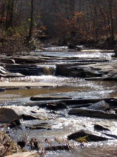
- Stevens Creek

The first crossing point
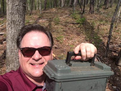
Modoc Stash in hand!
The hike was fun. Early spring in South Carolina with the trees budding and some species of wildflowers in bloom is lovely. If you are interested in birds, there is no shortage of variety from songbirds to the big raptors and wild turkey. The cool temps, in the low 60s, with a breeze kept the bugs to a minimum. Once I was within 200 feet of the cache location, left the trail to head to “ground zero.” Going off trail here is not a difficult bushwhack. Once I was within 20 feet, I switched from my handheld GPS to my eyes and my “geosenses.” Within a minute of getting to the general area, I had the ammo can in my hand. I traded some trackable items and signed the log. It was time to head back to the Jeep and get back on the road to Savannah.
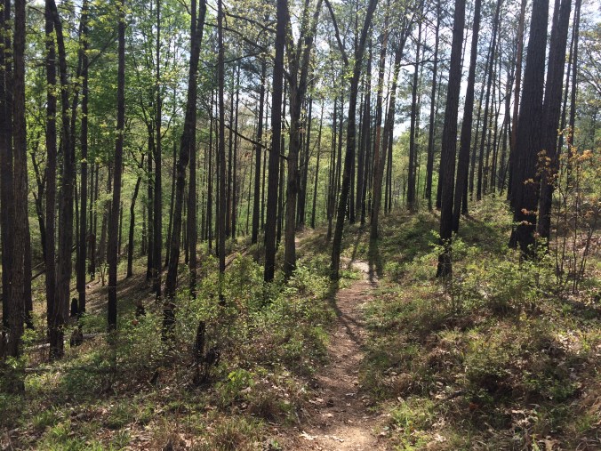
The trail on the hike out.
I took a little over an hour to complete the hike and find three Geocaches. I actually had a strong signal on my iPhone that enabled me to do a preliminary log for all the caches and document the trackable items exchanged at the old cache.
From the trailhead parking area, it took about three hours to complete the trip to Savannah. I was at my destination around 7:30 p.m. in time to get cleaned up and go out for dinner.
The next Geocaching road trip for me will be to collect a group of Y2K Geocaches in northeast Georgia. One will require a boat to get me out to an island in Lake Lanier. A friend of mine completed that grouping a couple of weeks ago. That trip will have to be more than just a detour on the way to Savannah! Perhaps I can convince Jeanne to partake in a little Geocaching adventure with me.
Click here if you would like more information the trails in the Sumter National Forest.


Great! now I have another must-do geocache to add to my list. Great write up.
LikeLike